WI
40° NIL
35 N
MS
30-
IN
TN
AL
KY
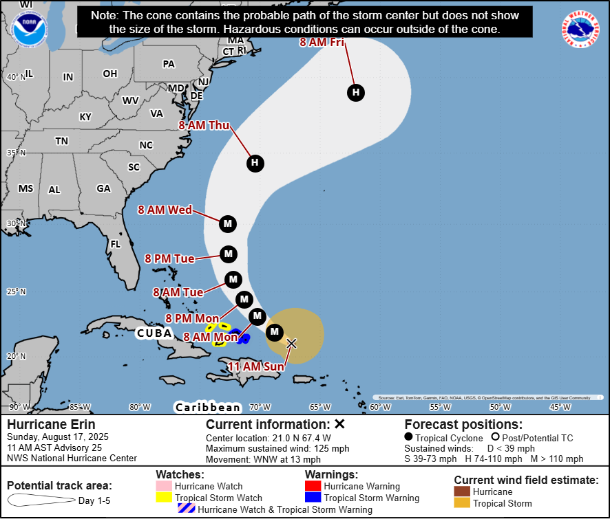
Note: The cone contains the probable path of the storm center but does not show the size of the storm. Hazardous conditions can occur outside of the cone.
MA
8 AM Fril
CT RI
ОН
WV
PA
NJ
UMD:
DE
8 AM Thu
GA
FL
25° N
•85%W
Hurricane Erin
Sunday, August 17, 2025 11 AM AST Advisory 25
NWS National Hurricane Center
Potential track area:
> Day 1-5
VA
NC
SC
8 AM Wed
8 PM Tue-
гон
BIAN TUE
8 PM Mon
CUBA 8 AM Mon 11 AM Sun
80° W
Caribbean
70°W
65° W
Ф. 60° W
Current information: X
Center location: 21.0 N 67.4 W
Maximum sustained wind: 125 mph
Movement: WNW at 13 mph
Watches:
Warnings:
Hurricane Watch
Tropical Storm Watch
Hurricane Warning
I Tropical Storm Warning
Hurricane Watch & Tropical Storm Warning
55° W
50° W
45° W
Forecast positions:
• Tropical Cyclone O Post/Potential TC
Sustained winds:
D < 39 mph
S 39-73 mph H 74-110 mph M > 110 mph
Current wind field estimate:
Hurricane
Tropical Storm