

San Francisco/Bay Area folks, we are trying to add a story to our Map. It's an address from 1950, 67 East Point Rd, San Francisco, but it doesn't seem to exist any more. Does anyone know where it was? Any assistance appreciated!
12
Replies
·
0
Boosts


@workingclasshistory here are a couple of views showing where East Point Road was. Most of the streets at the top Hunters Point were changed in the 70s redevelopment thanks for the heads up @bethwinegarner
2 media




@workingclasshistory Maybe this will help you https://www.foundsf.org/Main_Page
@workingclasshistory Maybe this will help you https://www.foundsf.org/Main_Page


Polk's Crocker-Langley San Francisco City Directory would have listings, and the San Francisco Public Library main branch has reference copies for in-building use.
Happily some of them are in the Internet Archive as well.
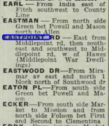
Here is a clip from the 1948-1949 directory, from here
https://archive.org/details/polkscrockerlang194849dire/page/n27/mode/2up?q=eastpoint
"middlepoint war dwellings" looks like a clue


Via the above guidance, it's on the 1950 Sanborn, Vol. 8, Sheet 814. Assessor's version is blurry but there's a clear ProQuest page via SF Public Library card access to Sanborn maps. Looks like the unit farthest east in Building 8F of the Middle Point War Dwellings. Inland from where Evans St. curves into Hunter's Point Blvd. near the India Basin small boat harbor. Possible this building might have been demolished while others in the complex became public housing?
Hm, no, appears the Hunters View public housing buildings weren't the same; they were built in the mid-1950s as successors to the war workers' housing. https://www.sfgate.com/bayarea/place/article/Hopeful-designs-in-Hunters-Point-projects-4958378.php And the Hunters View buildings have in turn been replaced by privatization/mixed-income construction under HOPE SF.
You can find more recent records for the area by going to https://sfplanninggis.org/pim/ and searching on 4603A005 . That is the block and lot number for what's now 1059-1075 Evans Street. I don't know if it is exactly the lot you want. but if you scroll down within the Assessor's search result page for that property, you'll find links to Sanborns and block maps of different ages, including the blurry version of the 1950 Sanborn.

On the 1950 Sanborn the long narrow building that appears to include the 67 East Point unit on its far right is the one nearest to a round ink mark on the edge of the drawing of Hunters Point Blvd, also nearest to the word "Blvd" in the label on the street.
