Discussion
Loading...
Post


Thanks to everyone who responded and donated. We value your feedback and support!

@organicmaps Will you share the results?


@organicmaps 2. and 5., please! :)


@organicmaps 1 traffic + 4 satellite imagery
A list of turn-by-turn directions for a destination would make trip planning easier.


@organicmaps I don't know how it is in other countries, but in the Czech Republic, the Organic Map app often provides directions that conflict with traffic regulations, such as turning at traffic lights.
@prozherin it is a common issue with OpenStreetMap data. The best way is to mark such crossings with "no turn" restriction in OpenStreetMap.org , or leave a note for other volunteers to fix: https://wiki.openstreetmap.org/wiki/Relation:restriction
@organicmaps Thank you so much for the advice!

@organicmaps
Definitely 5, it's the major show stopper for me. But also 2 is important. Less than those two, 3 and 4. But 5 is definitely what put me off


@organicmaps Sometimes I wish there was an option for the routing that would automatically add sufficient stops at EV charging facilities.


@organicmaps
1 & 7 would be neat


5. Better search and routing with the ability to show and select alternative routes.
x. Locally, on the device - the ability to mark points and sections of roads that are inaccessible (and set how long this will be the case). It would be good if this feature were also available globally online, with the ability for users to enable and disable it.
y. Passive navigation mode (i.e., following the map at your current location, but with your current speed and speed limits displayed).
z. Warning signal when speeding (of course, with the option for users to turn it off and set the frequency: only at the beginning, constant, for e.g. x seconds, etc.).


@usernaut Where/what can we improve?


@organicmaps
I use it when in a train. But when I zoom out I only see highways. It would be fine also seeing the main rail tracks. Perhaps as option.
@Joe_von_Saporski yes, in public transport mode. Good idea.

@organicmaps
1, 2, 3, 4, 6
Better with sharing collected user data (traffic, reviews, etc.) with other open projects
@ekatyshev yes, it is feasible, if it doesn't do any harm. Someone still should pay the bills for development, support, and servers/downloaded data.
![[ πɑ@Betty_Fn0rd ~ ]$ 🏳️⚧️✨](https://media.tech.lgbt/accounts/avatars/114/794/733/855/642/986/original/e4a0acf0273fa3b3.png "[ πɑ@Betty_Fn0rd ~ ]$ 🏳️⚧️✨")

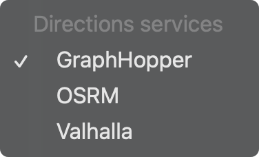
5:
As per OpenStreetMaps, a choice of directions service (see screenshot). Because routing can vary significantly between GraphHopper, OSRM and Valhalla.
Thanks for considering!


@organicmaps Postal codes for houses or offices.
@eobeara which country are you in? Adding postal codes can be done directly to OpenStreetMap.org , or using Organic Maps Editor.
@organicmaps Hi, I'm in Ireland, so we have Eircodes. I'll check that out, thanks for replying.

Traffic & Accident info by a country mile. It's the only thing preventing me using it as the sole app for travel.


@organicmaps 2 is a big missing

@organicmaps Yeah, public transport is the one thing I miss (and thus still use google maps when I need to check transport options).
P.S. Maybe it's not really important in US but here in Europe the public transport is crucial.


@organicmaps For me traffic info is the most important - I guess you could do a poll about that
@nictakiego poll is a good idea, although the results are generally biased depending on the audience type. E.g. votes of existing users may be radically different from votes of _potential_ users. It is great to hear direct feedback/comments, as OM doesn't collect any info, we rely on our users' feedback to build a better maps app.
@organicmaps well, you would know at least what most following people on mastodon think about those features. Better this than nothing

1. Public transport would be great.
5. With routing, it would be nice to have a way of forcing a route via a particular road for example. Sometimes, when I try and add intermediate points, and I get close, but don't actually get to the point, it keeps trying to send me back there, and there's no easy way to delete the point once i'm past it so it ignores it, especially while driving...
@chewie It could be related to "avoid" options or wrong OpenStreetMap.org map data. Maybe you can share some cases like this one to investigate?
@organicmaps I think the data was alright, I was trying to avoid a bridge with a weight limit on it, so I picked an intermediate road nearby, which I didn't go down in the end (probably due to roadworks or something), and it was difficult to easily remove the point - my gf was in control of the phone at the time as I was driving, so couldn't really see what was going on.
I'll try and get an actual example when I can.


@organicmaps
Public transport mainly bus infos
Searching for something is both long and inaccurate


@emla139 @organicmaps For public transport I'd always prefer the local service, because schedules can change quickly because of road work, accidents etc.
What I'd need however is a way to quickly spot bus or tram stops on the map so I can continue navigating with OSM on foot. Say, a highlight function or at least a good search (current is often congested with synonym street or building names). Also, bus stops are often hard to find at main stations with umpteen lines.

@organicmaps Public transport is the biggest reason I sometimes have to open other mapping apps.
Also, businesses information such as opening hours.
@shantara PT is in development, business info depends on contributions to OpenStreetMap.org and on everyone of us. It is easy to add missing opening hours using Organic Maps btw.


Elevation profile for car routes.

@organicmaps I'm just here to wait for GPS track import with turn by turn Navigation
@starfrosch GPX, KML, KMZ, GeoJSON tracks can be imported already. Track navigation is planned!
@organicmaps Nice, track navigation eta?


@organicmaps
9. The current speed and current speed limit displayed on screen when in follow-along-mode (I.E not navigating). Bonus points if it beeps when going over the speed limit.
Current speed would also be useful when following .GPX route overlays on a bicycle.
However, smaller map updates would be good too, as maps are quite large.
@Isthmus what is your use case for a "free riding" mode (when navigation is not active)?
@organicmaps
When in a car, so I can easily see the speed limit of the road I'm driving on. It's easy to go over the speed limit even in places you know and it's a PITA to set navigation just to be reminded when exceeding the speed limit. Ideally it would beep when going over the speed limit too – such as three short beeps when exceeding the speed limit and the speed turns red.
When on a bicycle, so I know my current speed when following pre-made GPX routes overlayed on Organic Maps. Otherwise, I would need a separate app running just for GPS speed and then have to keep switching between the two – which is just not practical. The information is already being calculated in Organic Maps (clicking on the "My Position" triangle will display it), it just doesn't currently display it in any useful way. It's too tiny to be of any use when moving – other than perhaps viewing the speed and altitude of the airplane you're on – where you won't be bouncing around over potholes.
When hiking or kayaking, well sometimes it's kinda nice to see what pace you're walking or paddling at too…


#Esperanto as an interface and data language. This is the breaking feature why I always recommend OsmAnd to other Esperanto speakers.
@organicmaps 2. Traffic info definitely

@organicmaps Displaying of via ferrata.


@organicmaps alternative cycling routes in case of steep climbs

@organicmaps
As a long-term daily driver, last week I went abroad and noticed that public transportation is missing and I don't have google services 😁
Other than that, night mode map should be improved. Text is very hard to read.

@organicmaps
Mainly 2, 4 and 7 (traffic, satellite & interface to osm editing)!
But I'll also happily take it as is, because it's absolutely great! Also has advanced these past years incredibly well (eg tracks!). I switched to it years ago and never looked back. 👍
@W_Lucht Thanks for your good words and support. It motivates!

o/
2, 3, 7
o/~
@organicmaps
2) traffic info


@organicmaps what about
9. different sets of icons for POIs


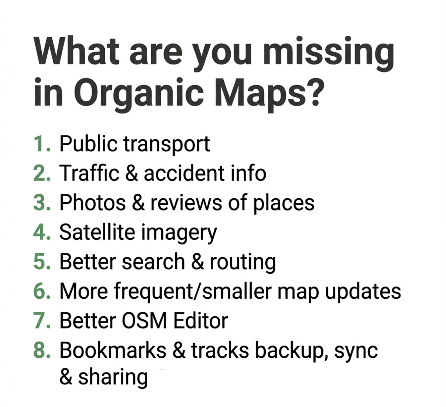
»What are you missing in Organic Maps?
1. Public transport
2. Traffic & accident info
3. Photos & reviews of places
4. Satellite imagery
5. Better search & routing
6. More frequent/smaller map updates
7. Better OSM Editor
8. Bookmarks & tracks backup, sync & sharing«
You need to log in to see that page.