Discussion
Loading...

#Tag

Log in
  • About
  • Code of conduct
  • Privacy
  • Users
  • Instances
  • About Bonfire
Journal of Alpine Research
@JARRGA@piaille.fr  ·  activity timestamp last month

#Legambiente presenta il VI report Carovana dei #Ghiacciai

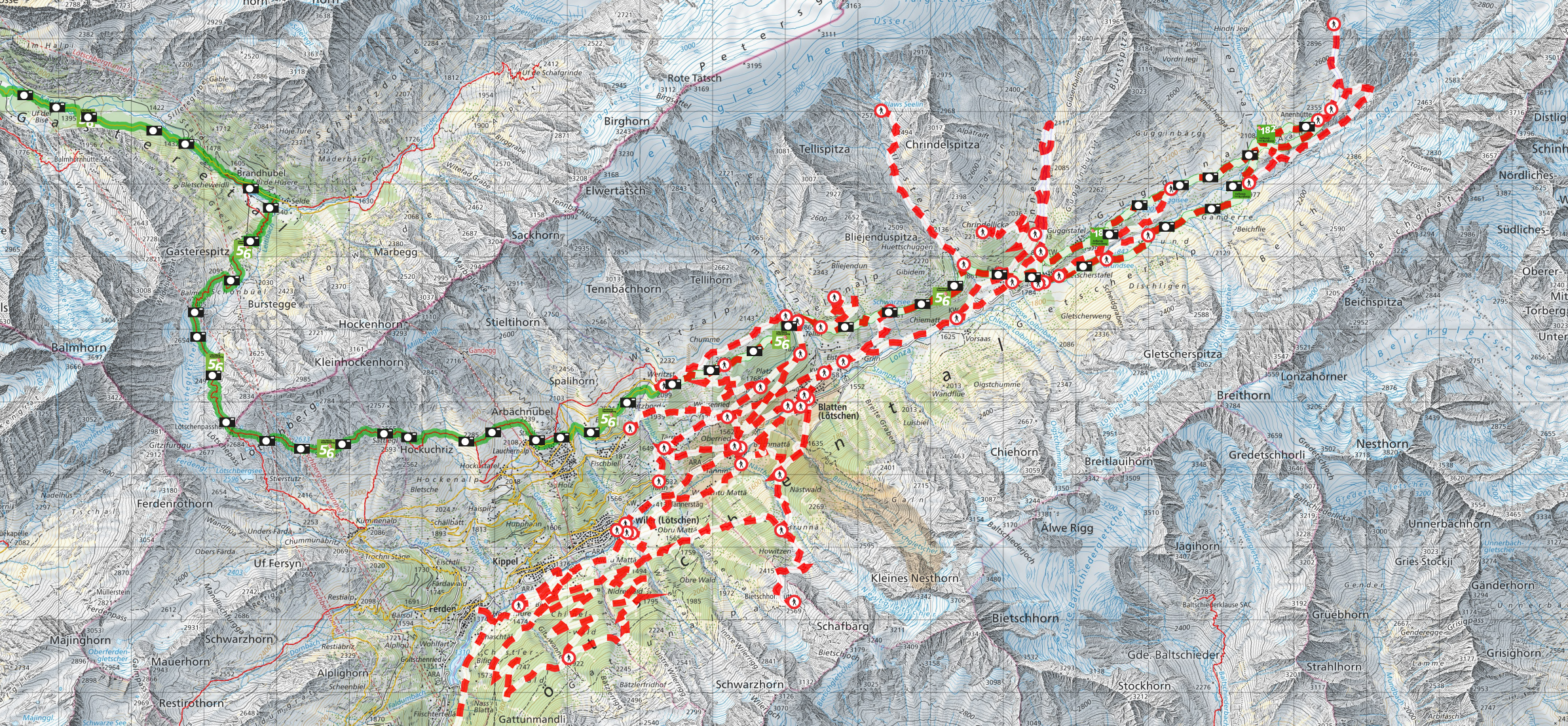
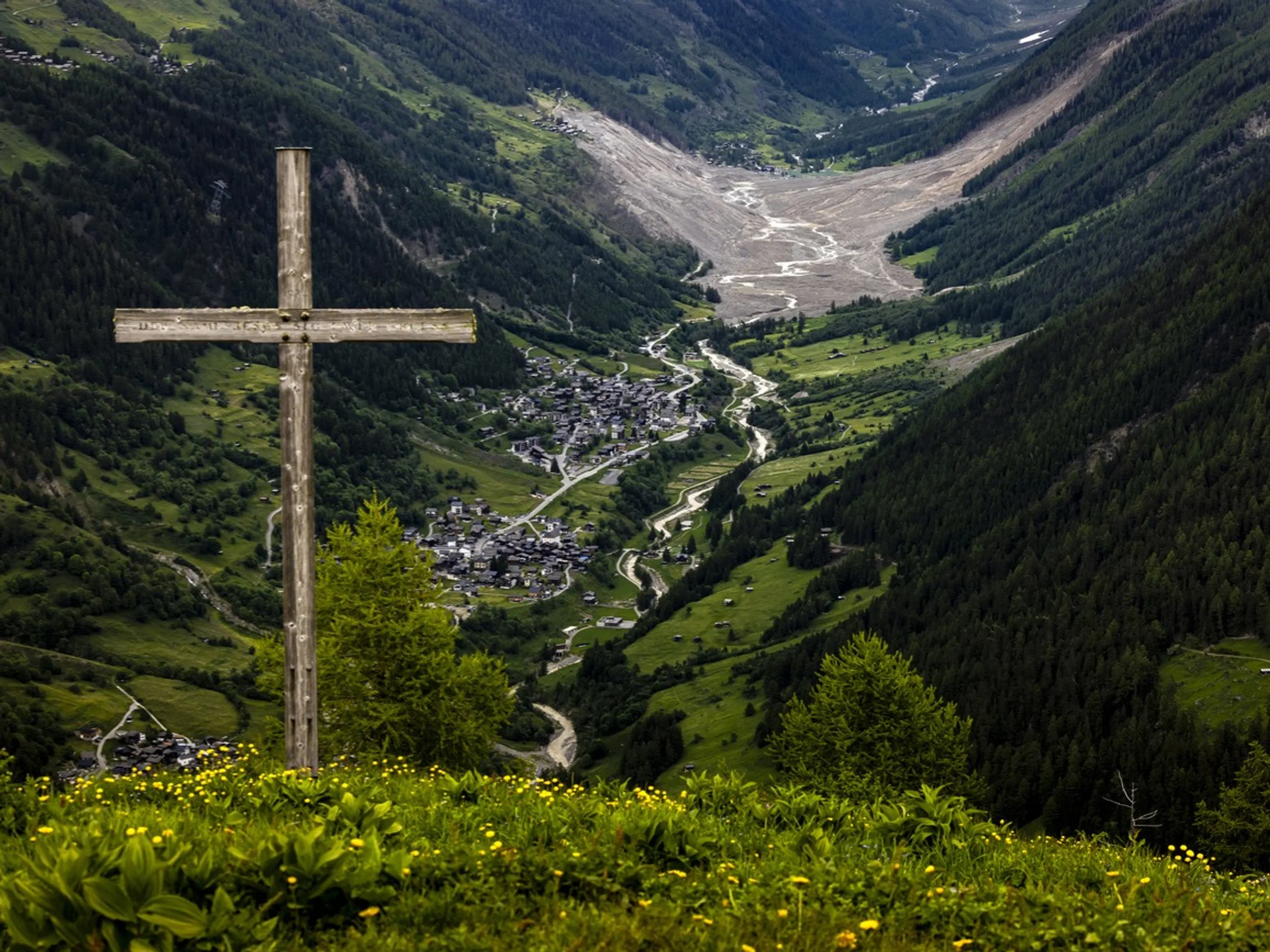
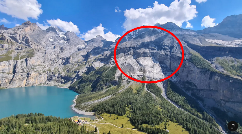
>> Le #Alpi siano sempre più fragili e instabili, con 40 eventi franosi documentati in alta quota, soprattutto crolli di roccia e colate detritiche per il solo 2025. Tra i casi simbolo: la valanga di roccia e ghiaccio di #Blatten in #Svizzera e le ripetute colate detritiche sull’ #Alemagna (BL). Ma in aumento sono anche gli eventi #meteo estremi: 154 quelli mappati in questi 11 mesi dell’anno in corso dall’Osservatorio Città #Clima di Legambiente nelle regioni dell’arco alpino.

via @legambiente:
https://www.legambiente.it/comunicati-stampa/nel-2025-alpi-e-ghiacciai-sempre-piu-fragili-e-instabili
#montagna #CambiamentoClimatico

Un gruppo di persone si tiene le mani in un cerchio attorno a uno striscione in cui si legge "European Manifesto for the governance of glaciers and connected resources"
  • Copy link
  • Flag this post
  • Block
Sander Meijer
Sander Meijer
@bergmeister@mountains.social  ·  activity timestamp 4 months ago

Nach Bergsturz in Blatten

Abgeschnitten auf 2300 Metern: Das Schicksal der Anenhütte

https://www.srf.ch/news/nach-bergsturz-in-blatten-vs-abgeschnitten-auf-2300-metern-das-schicksal-der-anenhuette

#MountainHuts #Blatten #Anenhütte

  • Copy link
  • Flag this post
  • Block
Sander Meijer
Sander Meijer
@bergmeister@mountains.social  ·  activity timestamp 6 months ago

Why glaciers are threatening to wipe out more mountain villages

https://www.bbc.com/news/articles/cj4w9ggzxv4o

#Glaciers#Blatten#ClimateChange#Mountains

  • Copy link
  • Flag this post
  • Block
Sander Meijer
Sander Meijer
@bergmeister@mountains.social  ·  activity timestamp 6 months ago

New models improve predictions of snow, rock and ice avalanches

A new 3D simulation tool developed by ETH and SLF researchers now allows for significantly more accurate predictions of complex alpine mass movements, supporting alpine risk management.

https://ethz.ch/en/news-and-events/eth-news/news/2025/07/new-models-improve-predictions-of-snow-rock-and-ice-avalanches.html

The model produces the most accurate simulation of the disaster in Blatten.

#Blatten #ETH #SLF #Avalanche #Geology

Your browser does not support the video tag.
This video cannot be previewed
Open original
A 3D model of the mountain above Blatten and the simulation of the rock- and glacier slide which hit the village some weeks ago.
  • Copy link
  • Flag this post
  • Block
Sander Meijer
Sander Meijer
@bergmeister@mountains.social  ·  activity timestamp 6 months ago

Ähnlich grosser Abbruch wie in Blatten nicht ausgeschlossen

In einem Informationsschreiben teilt die Gemeinde Kandersteg mit, dass ein grosser Abbruch am Spitze Stei nicht ausgeschlossen ist, aber zum Restrisiko gehört. Murgänge sind wahrscheinlicher.

Ähnlich grosser Abbruch wie in Blatten nicht ausgeschlossen
https://www.20min.ch/story/kandersteg-spitze-stei-aehnlich-grosser-abbruch-wie-in-blatten-nicht-ausgeschlossen-103375544

#Blatten#SpitzeStei#Kandersteg#Bergen#Mountains

  • Copy link
  • Flag this post
  • Block
Sander Meijer
Sander Meijer
@bergmeister@mountains.social  ·  activity timestamp 7 months ago

Aktuell gesperrte Wanderwegen im Lötschental

#Blatten

Swisstopo Karte mit gesperrten Wanderwegen
  • Copy link
  • Flag this post
  • Block
Sander Meijer
Sander Meijer
@bergmeister@mountains.social  ·  activity timestamp 7 months ago

Auf der Swisstopo Karte ist jetzt auch Standard das Bergstutzgebiet eingezeichnet:

https://s.geo.admin.ch/0v67jmz0gh31

#Blatten

  • Copy link
  • Flag this post
  • Block
Sander Meijer
Sander Meijer
@bergmeister@mountains.social  ·  activity timestamp 7 months ago

Lötschental öffnet wieder für Touristen – und hofft auf Gäste

https://www.srf.ch/news/nach-bergsturz-in-blatten-loetschental-oeffnet-wieder-fuer-touristen-und-hofft-auf-gaeste
#Blatten

Lötschental mit Schuttegel. Im Vordergrund ein Gipfelkreuz.

Picture by KEYSTONE/Michael Buholzer
Lötschental mit Schuttegel. Im Vordergrund ein Gipfelkreuz. Picture by KEYSTONE/Michael Buholzer
  • Copy link
  • Flag this post
  • Block
Sander Meijer
Sander Meijer
@bergmeister@mountains.social  ·  activity timestamp 8 months ago

After what happened in Blatten, it might be good to be reminded of the situation near Kandersteg with the "Spitze Stei" (Pointy Rock).

To start with: currently there is NO acute risk of rockslides and the situation it NOT directly comparable with Blatten.

What is comparable though, is that fact the the instability of the mountain is most likely related to the thawing of permafrost. Where in Blatten 3-5 million cubic meters came down, the Spitze Stei area that is moving is approx 16 million cubic meters in size. There is no glacier involved where the rocks might fall on as in Blatten, but the debris flow might cause a flooding of Lake Oeschinen, which poses a risk for the village of Kandersteg downstream.

I'm not trying to cause panic, the situations are not directly comparable and there is no indication things are speeding up (currently moving with approx 0.4 cm per day). It does however show that instability of mountains because of thawing of permafrost is a broader phenomenon than "just" Blatten.

A previous threads on Spitze Stei:

https://mountains.social/@bergmeister/112659989247160864

Website of village of Kandersteg with updated info on Spitze Stei:

https://www.gemeindekandersteg.ch/spitze-stei

#Blatten#Kandersteg#SpitzeStei

Aerial picture of Lake Oeschinen with in a red circle the area around Spitze Stei.
  • Copy link
  • Flag this post
  • Block
Sander Meijer
Sander Meijer
@bergmeister@mountains.social  ·  activity timestamp 8 months ago

The Swiss village wiped off the map by a glacier

https://www.bbc.co.uk/news/resources/idt-c7f929de-96a9-45e5-b1bb-31de82fce72d

#Blatten

  • Copy link
  • Flag this post
  • Block

bonfire.cafe

A space for Bonfire maintainers and contributors to communicate

bonfire.cafe: About · Code of conduct · Privacy · Users · Instances
Bonfire social · 1.0.1-beta.35 no JS en
Automatic federation enabled
Log in
  • Explore
  • About
  • Members
  • Code of Conduct