We can prevent flood impacts if we understand rivers better

Rivers don’t just carry water from point A to point B. They meander, braid, shift, and carve landscapes.

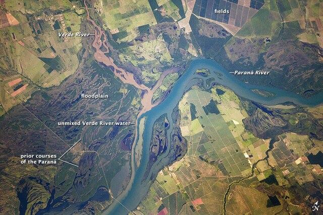
This is how floodplains are formed.

Floodplains provide the space for the additional water to fill out, reduce floods peaks downstream and store sediments.

They also support diverse habitats including wetlands, lakes, and swamps

An example, these floodplains in the Parana river (Brazil)

#Floods

The image is an aerial view of a river system, featuring the Verde River and the Paraná River. The Verde River, labeled on the left, flows into the Paraná River, which is labeled on the right. The area is characterized by a mix of agricultural fields and natural landscapes. The Paraná River is shown in a lighter blue, indicating its main channel, while the Verde River appears in a darker brown, suggesting sediment-rich water. The floodplain is visible as a darker area adjacent to the rivers, indicating the land that is periodically flooded. The image also highlights "unmixed Verde River water" and "prior courses of the Paraná," suggesting historical river paths. The fields are depicted in various shades of green and brown, with some areas appearing more developed than others. The image provides a comprehensive view of the river system and its surrounding environment.

Provided by @altbot, generated privately and locally using Ovis2-8B

🌱 Energy used: 0.183 Wh
The image is an aerial view of a river system, featuring the Verde River and the Paraná River. The Verde River, labeled on the left, flows into the Paraná River, which is labeled on the right. The area is characterized by a mix of agricultural fields and natural landscapes. The Paraná River is shown in a lighter blue, indicating its main channel, while the Verde River appears in a darker brown, suggesting sediment-rich water. The floodplain is visible as a darker area adjacent to the rivers, indicating the land that is periodically flooded. The image also highlights "unmixed Verde River water" and "prior courses of the Paraná," suggesting historical river paths. The fields are depicted in various shades of green and brown, with some areas appearing more developed than others. The image provides a comprehensive view of the river system and its surrounding environment. Provided by @altbot, generated privately and locally using Ovis2-8B 🌱 Energy used: 0.183 Wh