Discussion
Loading...

Discussion

  • About
  • Code of conduct
  • Privacy
  • Users
  • Instances
  • About Bonfire
Phil Stooke
@PhilStooke@mastodon.social  ·  activity timestamp 3 weeks ago

Venera 10 landed in the area shown here at two scales - at left a map spanning 500 km shows major landforms, at right, full Magellan resolution gives us details of part of the landing ellipse. We see mixed geology - the dark areas are smooth (ish) plains, probably sediments blown around by the wind. What makes sediment on Venus? Impacts, chemical weathering and maybe volcanic ash. A big bright area (Hyndla Regio) is an upland cut by many faults.
#venus #venera10

Two maps of the Venera 10 landing site. At left a context map shows bright and dark areas, the bright parts being a hilly area cut by many faults and the dark areas being smoother surfaces probably covered with sediments.  A mountain in the south part of the map is a volcano, and flows extend from it to the north and east. Venera 10 could have landed anywhere in a 300 km diameter circle filling much of the map. At right the central part of that landing region is shown in more detail revealing plains cut by ridges and fractures, and part of the hilly area.
Two maps of the Venera 10 landing site. At left a context map shows bright and dark areas, the bright parts being a hilly area cut by many faults and the dark areas being smoother surfaces probably covered with sediments. A mountain in the south part of the map is a volcano, and flows extend from it to the north and east. Venera 10 could have landed anywhere in a 300 km diameter circle filling much of the map. At right the central part of that landing region is shown in more detail revealing plains cut by ridges and fractures, and part of the hilly area.
  • Copy link
  • Flag this post
  • Block
Phil Stooke
@PhilStooke@mastodon.social replied  ·  activity timestamp 3 weeks ago

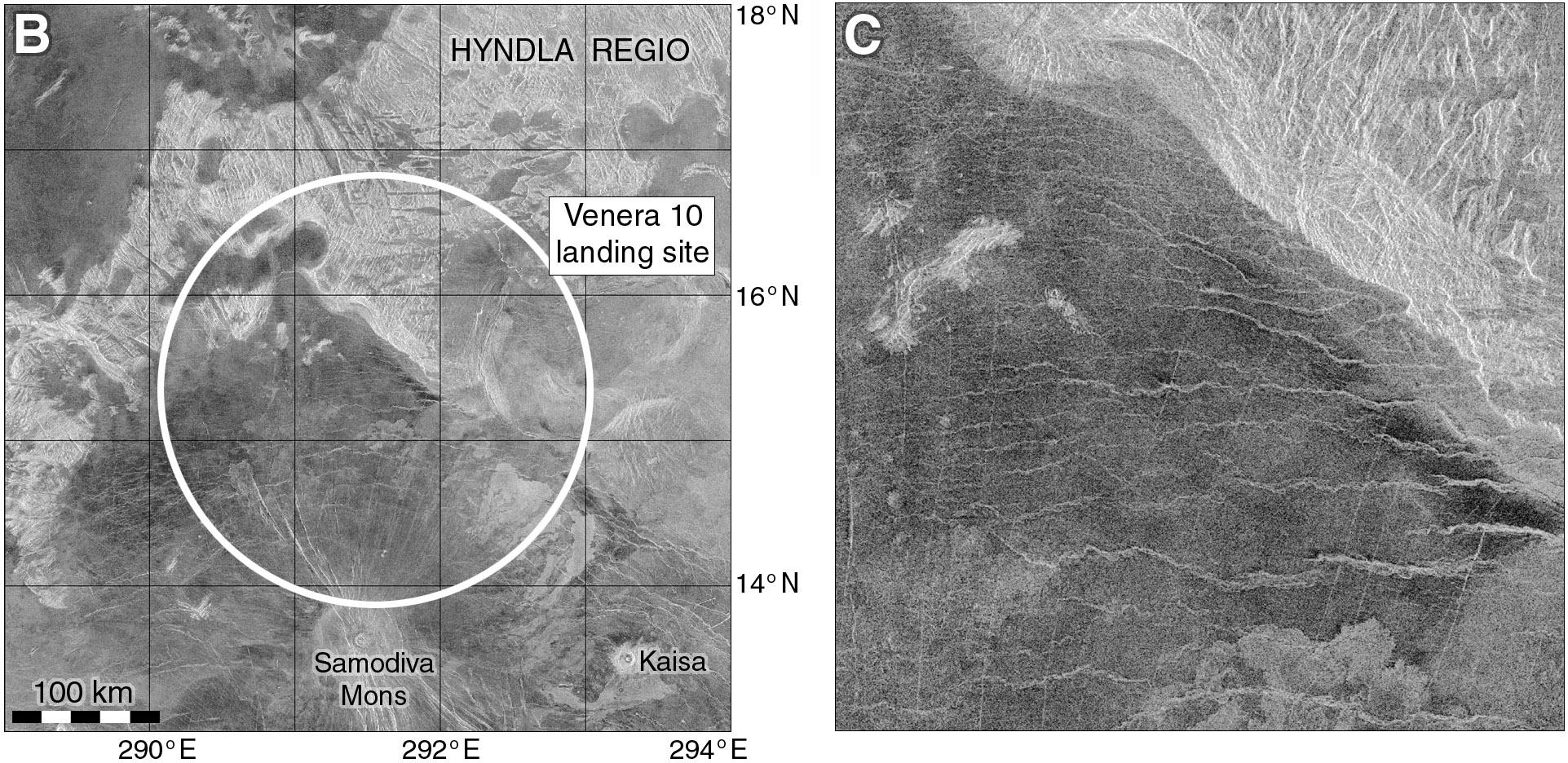
The south part of the map contains a large volcanic shield (Samodiva Mons) which has released lava flows showing up as brighter lobate markings extending north and east from the shield. The 300 km circle is the landing location - it could be anywhere in there. The closeup, 100 km wide, shows the plains cut by ridges (east-west) and fractures (north-south). The bright hills are cut by many fractures. Little domes at the left edge are small volcanoes. What did Venera 10 land on?
#venus #venera10

  • Copy link
  • Flag this comment
  • Block
Phil Stooke
@PhilStooke@mastodon.social replied  ·  activity timestamp 3 weeks ago

If Venera 10 landed in the hills, I might expect a landscape similar to that at Venera 9's site, lots of blocks where the rock has been broken by dense patterns of faults. But it didn't see that. Tomorrow we will see what the second image of the surface of Venus revealed.
#venus #venera10

  • Copy link
  • Flag this comment
  • Block
Phil Stooke
@PhilStooke@mastodon.social replied  ·  activity timestamp 3 weeks ago

OK, what did Venera 10 see? This is the link I gave earlier to Don Mitchell's page about Venus images:

http://mentallandscape.com/C_CatalogVenus.htm

and here is the raw Venera 10 image:

http://mentallandscape.com/C_Venera10.jpg

His expert processing gives us this:

http://mentallandscape.com/C_Venera10_Processed.jpg

(raw, gaps filled from second image, remaining gaps filled by interpolation)

Both of these Venera landers carried a second camera on the opposite side of the lander, but in each case it failed to operate.
#venus #venera10

  • Copy link
  • Flag this comment
  • Block
Phil Stooke
@PhilStooke@mastodon.social replied  ·  activity timestamp 3 weeks ago

Here is an old Soviet version of the Venera 10 image, a bit too contrasty so details get lost especially at the horizon. But what we see is different from Venera 9's boulders. This is a nearly flat area with platy slabs of rock interspersed with darker gravelly soil. One of the rocky slabs is cracked. The two objects are a densitometer to measure surface hardness and a lens cover ejected from the camera after landing.
#venus #venera10

A Russian image of the Venera 10 panoramic image. It extends from horizon to horizon at left and right, and shows the foreground in the middle. Flat slabs of rock cover about half of the surface with gravelly soil between them. Two objects sit on the surface, a lens cover from the camera and a densitometer instrument on a short arm which was dropped on the surface o measure its hardness.
  • Copy link
  • Flag this comment
  • Block
Phil Stooke
@PhilStooke@mastodon.social replied  ·  activity timestamp 3 weeks ago

We have seen the Venera 9 and 10 panoramas, but take a look at this from the Planetary Society:

https://www.planetary.org/space-images/rectified-vs-original-venera-9-and-10-panoramas

(presented without any explanation on that page). This version has more detail:

https://www.planetary.org/space-images/standing-on-venus-with-venera-10

These are artistic re-workings of the panoramas, rearranging bits of the images to create a more understandable view. I show them because they pop up in image searches and are often misrepresented as original images.
#venus #venera10

  • Copy link
  • Flag this comment
  • Block
Log in

bonfire.cafe

A space for Bonfire maintainers and contributors to communicate

bonfire.cafe: About · Code of conduct · Privacy · Users · Instances
Bonfire social · 1.0.1-alpha.8 no JS en
Automatic federation enabled
  • Explore
  • About
  • Members
  • Code of Conduct
Home
Login