Discussion
Loading...

Discussion

Log in
  • About
  • Code of conduct
  • Privacy
  • Users
  • Instances
  • About Bonfire
Chee Aun 馃
@cheeaun@mastodon.social  路  activity timestamp last week

Here鈥檚 a series of side quests on my other side projects:

1. WBGT (Wet Bulb Globe Temperature) readings are now displayed as 馃敟 on https://checkweather.sg/

Open-source: https://github.com/cheeaun/checkweather-sg
Data from data.gov.sg: https://data.gov.sg/datasets/d_87884af1f85d702d4f74c6af13b4853d/view

#Singapore

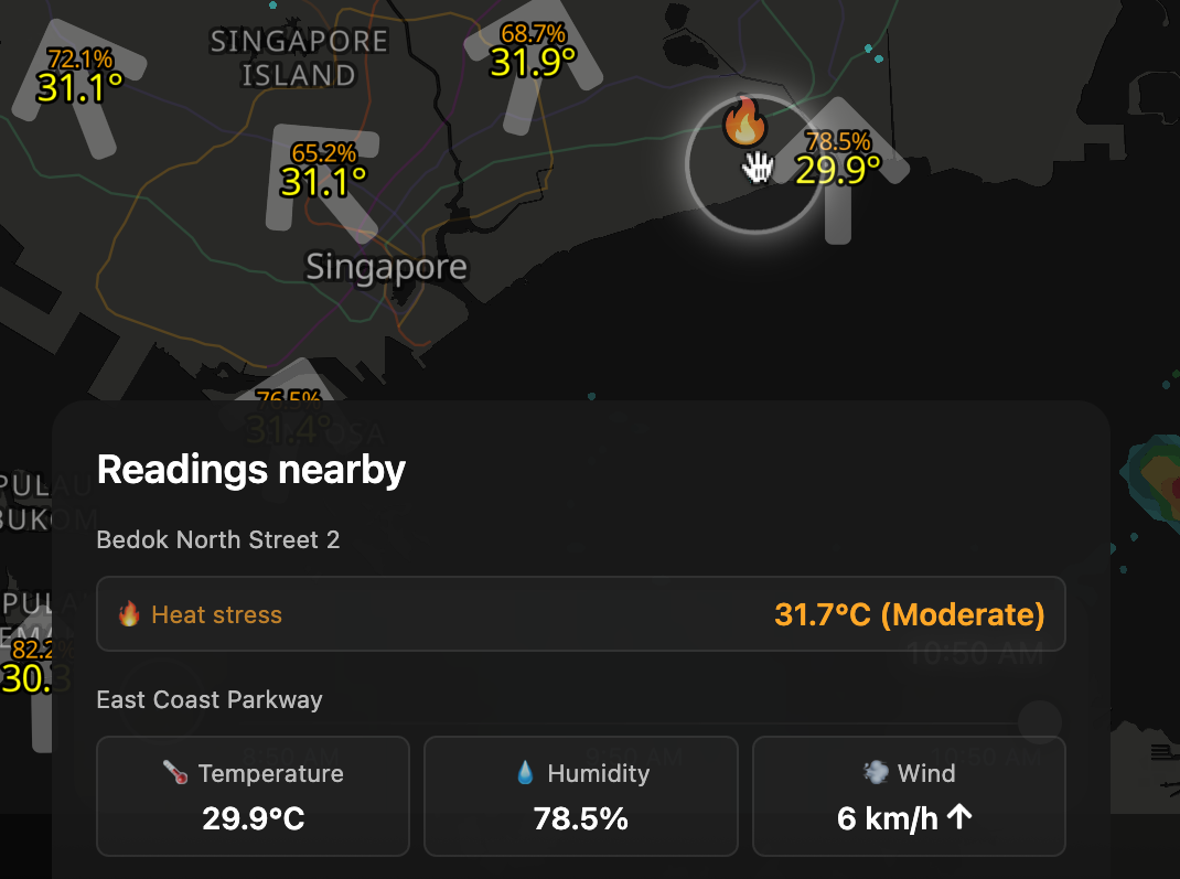
Map showing weather readings near Bedok North Street 2, highlighting heat stress with a moderate level of 31.7掳C. Another reading near East Coast Parkway showing temperature at 29.9掳C, humidity at 78.5%, and wind speed of 6 km/h.
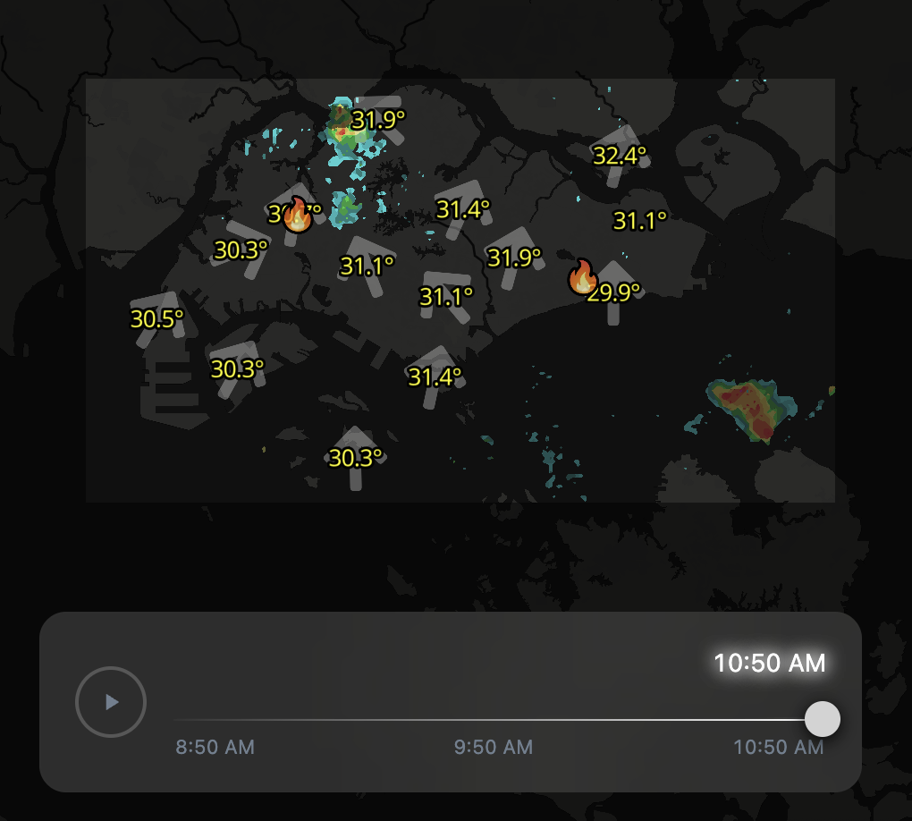
Weather map showing temperatures around 30-32掳C with wind directions and light precipitation areas, including two flame icons indicating heat stress, timestamped at 10:50 AM.
  • Copy link
  • Flag this post
  • Block
Chee Aun 馃
@cheeaun@mastodon.social  路  activity timestamp last week
  1. Hume, Punggol Coast and Stage-4 Thomson-East Coast line stations are now on https://railrouter.sg

    Open-source: https://github.com/cheeaun/railrouter-sg
    Data here: https://github.com/cheeaun/sgraildata

    #Singapore

Map showing Stage-4 Thomson-East Coast Line, including areas like Marina South Pier, Gardens by the Bay, Bayfront, Nicoll Highway, Tanjong Katong, Marine Parade, Siglap, and Bayshore.
Map showing the Tanjong Katong MRT station (TE25) on the Thomson-East Coast Line in Singapore, with surrounding buildings and roads including Amber Skye, NYON, Aalto, and Jalan Seaview.
Map showing the location of Hume MRT station (DT4) on the Downtown Line, near Upper Bukit Timah Road and Rail Corridor.
  • Copy link
  • Flag this comment
  • Block
Chee Aun 馃
@cheeaun@mastodon.social  路  activity timestamp last week
  1. It also now renders Tamil characters properly, thanks to https://github.com/wipfli/maplibre-gl-complex-text (found via https://hachyderm.io/@skinnylatte/114400130119630384)

    Here's a before and after comparison.

    #Singapore

Map showing Chinatown MRT station in Singapore with NE4 and DT19 lines, nearby landmarks, and exit points labeled A to F.

Before: Tamil characters rendered correctly.
Map showing Chinatown MRT station in Singapore with NE4 and DT19 lines, nearby landmarks, and exit points labeled A to F. Before: Tamil characters rendered correctly.
Map showing Chinatown MRT station (NE4, DT19) in Singapore, with nearby buildings and exits D, E, and G highlighted.

Before: Tamil characters rendered wrongly.
Map showing Chinatown MRT station (NE4, DT19) in Singapore, with nearby buildings and exits D, E, and G highlighted. Before: Tamil characters rendered wrongly.
  • Copy link
  • Flag this comment
  • Block
Log in

bonfire.cafe

A space for Bonfire maintainers and contributors to communicate

bonfire.cafe: About 路 Code of conduct 路 Privacy 路 Users 路 Instances
Bonfire social 路 1.0.0-rc.1.31 no JS en
Automatic federation enabled
  • Explore
  • About
  • Members
  • Code of Conduct