Discussion
Loading...

Discussion

Log in
  • About
  • Code of conduct
  • Privacy
  • Users
  • Instances
  • About Bonfire
Information Is Beautiful
@infobeautiful@vis.social  ·  activity timestamp 7 months ago
https://medium.com/enrique-dans/connectivity-is-the-key-to-africa-s-growth-94a0dd91364b

by @Medium

Map of the continent of Africa outlined in black, with various countries and regions overlaid to demonstrate their relative sizes compared to parts of Africa. The United States (in dark purple) covers a significant portion of North and West Africa. China (in red) covers a large part of Central and Southern Africa. India (in orange) is shown in East Africa. Several European countries are placed in the northwest: Spain (brown), France (purple), Germany (yellow), Italy (green), Netherlands (light purple), Belgium (dark purple), Switzerland (light blue), Portugal (light brown), and the UK (blue) is shown off the southeastern coast. Eastern Europe (blue) is situated in the northeast. Japan (yellow) is a long, narrow shape along the southeastern coast. China (smaller part in light red) and India (smaller part in light orange) are also shown in the Horn of Africa region.
  • Copy link
  • Flag this post
  • Block
Robin Barton
Robin Barton
@Robo105@mastodon.social replied  ·  activity timestamp 7 months ago
@infobeautiful Very good indeed
  • Copy link
  • Flag this comment
  • Block
Log 🪵
Log 🪵
@log@mastodon.sdf.org replied  ·  activity timestamp 7 months ago
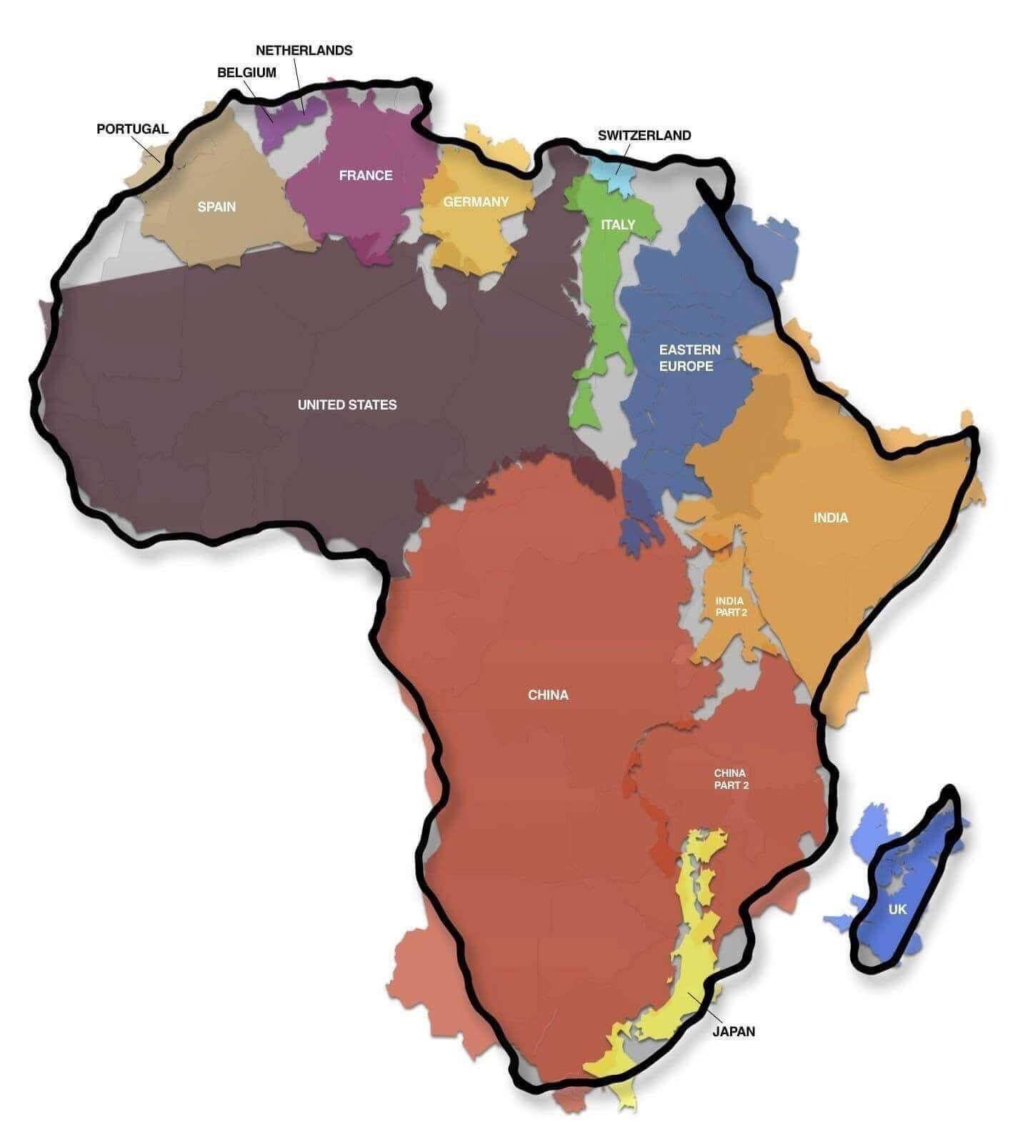
@infobeautiful "New colonialism map, go! Everyone get out to your assigned areas and get to exploiting!"

Infographic artist: [Horrified expression, extended Sideshow Mel groan.]

  • Copy link
  • Flag this comment
  • Block
Kevin Russell
Kevin Russell
@kevinrns@mstdn.social replied  ·  activity timestamp 7 months ago
@infobeautiful

Nice

  • Copy link
  • Flag this comment
  • Block
Clifford Oliver
Clifford Oliver
@cliffco58@mstdn.party replied  ·  activity timestamp 7 months ago
@infobeautiful Africa hasn't belonged to Africans for centuries.
  • Copy link
  • Flag this comment
  • Block
John Maxwell
John Maxwell
@jmax@mastodon.social replied  ·  activity timestamp 7 months ago
@infobeautiful That's some radical continental drift.
  • Copy link
  • Flag this comment
  • Block
HuisOpDeGaard 🇾🇪 🇪🇺 🇺🇦
@huis@mastodon.social replied  ·  activity timestamp 7 months ago

IMMAPPANCY

@infobeautiful Not only is the blogpost 15 years old…that author of the post did not do a very goog job in referencing the ‘Africa-image’ to it’s original author; http://kai.sub.blue/en/africa.html

He ‘coined’ the term “ “immappancy”, meaning in-
sufficient geographical knowledge.” adressing “the highly distorted nature of the predominantly used mapping projections (such as Mercator).”

The full map and adjoining info is avalable as a download (CC).
#kaikrause #mercator #immappancy

Sorry, no caption provided by author
  • Copy link
  • Flag this comment
  • Block
Ruby
Ruby
@Rubelicious@mastodon.ie replied  ·  activity timestamp 7 months ago
@infobeautiful shame that the author threw Ireland in as part of the UK 🙄
  • Copy link
  • Flag this comment
  • Block
millennial fulcrum
millennial fulcrum
@falcennial@mastodon.social replied  ·  activity timestamp 7 months ago
@infobeautiful I legitimately thought this was a geopolitical map and I was like well then where the fuck are the russia terrorists then
  • Copy link
  • Flag this comment
  • Block
guenther
guenther
@guenther@chaos.social replied  ·  activity timestamp 7 months ago
@infobeautiful oh no, we're Libya :(
  • Copy link
  • Flag this comment
  • Block

bonfire.cafe

A space for Bonfire maintainers and contributors to communicate

bonfire.cafe: About · Code of conduct · Privacy · Users · Instances
Bonfire social · 1.0.1-beta.35 no JS en
Automatic federation enabled
Log in
  • Explore
  • About
  • Members
  • Code of Conduct