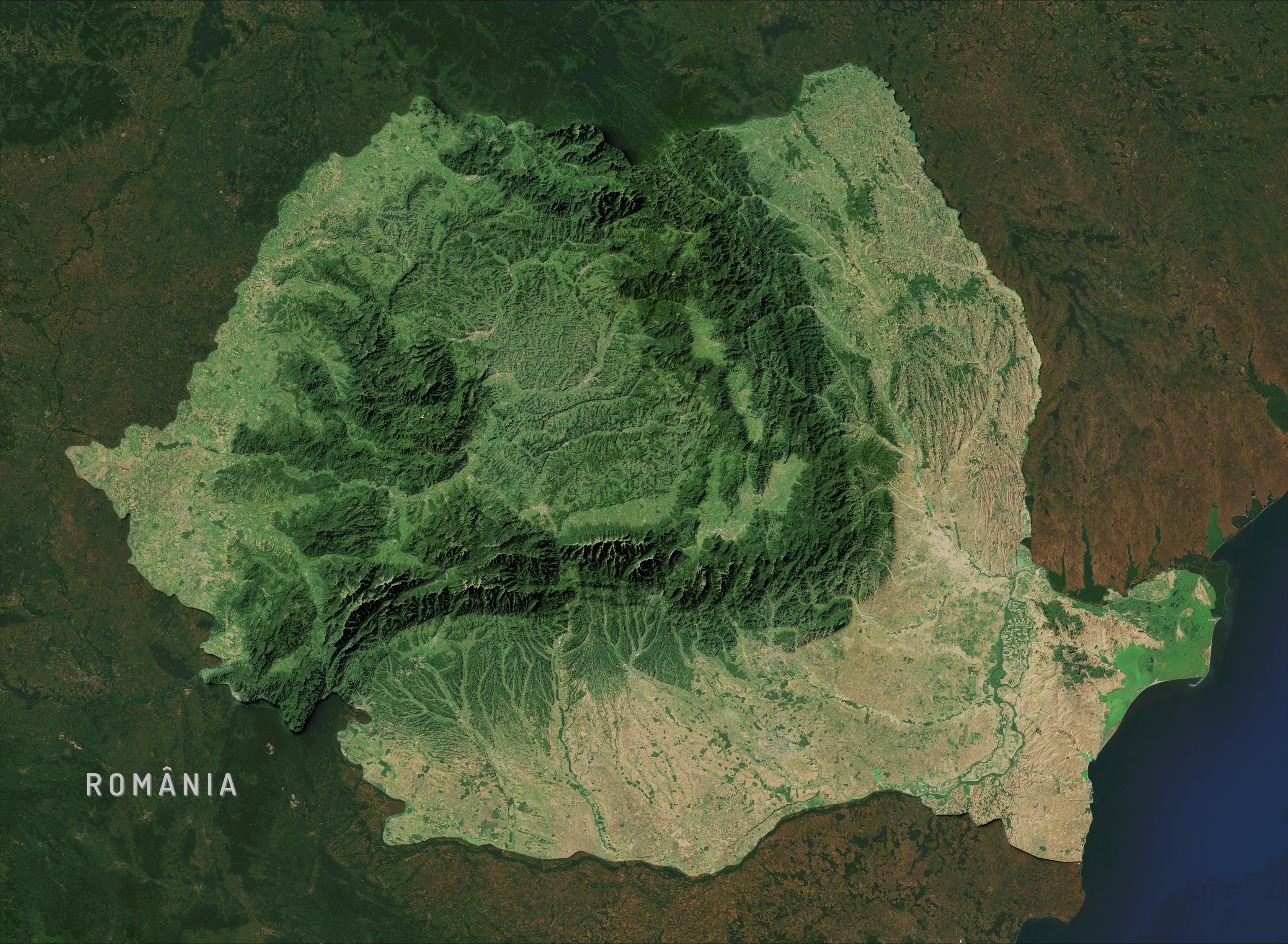
🌊 hashtag#30DayMapChallenge Day 20: Water
Estaba intentando recrear el estilo de relieve de Eduard Imhof con software libre cuando, por accidente, subí un poco el nivel del mar. Me gustó cómo eso destacó el contraste entre la hidrografía y el relieve.
Usé GIMP y QGIS, tomando como referencia los trabajos de @john_m_nelson y Tom Patterson. #GIMP #QGIS #Cartography
#QGIS supports a "Model builder" that will allow you to chain a selection of these algorithms together with data you have.
At the end of the pipeline, you can give weights to each of the component pieces for a final priority that balances safety, utility and equity in sidewalk planning!
Here's a heatmap of locations with missing sidewalk, shaded based on priority to fund. 🧵
Another #UrbanPlanning algorithm I plan to pick back up is like "Percent High Comfort BikeShed" (or WalkShed).
The idea is compute the area from a given a location that you bike to within 15 minutes and then the area that bike to *with high comfort*, like protected bike lanes and so forth. Divide them to get the "Percent High Comfort Bikeshed" for that location.
"Percent High Comfort Bikeshed" may be harder to package for #QGIS because it involves running a custom #valhalla server currently-- building a graph to generate the bike isochrones (travel-time area) using only the high-comfort facilities.
If there's a way to query Valhalla such that only a subset of the network is considered for routing, then I could run it against public servers.
The current iteration of the plugin generates a starter hex grid for you.
The expanded version will support "bring your own hex grid", so you can start with a grid and then continue add more values to it which are then used to build a priority score.
This final step is described more here, in How to Create a Heatmap of Sidewalk Location Priority:
https://mark.stosberg.com/how-to-create-a-heatmap-sidewalk-location-priority/
🧵
Early feedback on the "Sidewalk Location Priority Toolkit" for QGIS is welcome.
Are you interested in something like this? What's helpful to you? Questions?
#QGIS supports a "Model builder" that will allow you to chain a selection of these algorithms together with data you have.
At the end of the pipeline, you can give weights to each of the component pieces for a final priority that balances safety, utility and equity in sidewalk planning!
Here's a heatmap of locations with missing sidewalk, shaded based on priority to fund. 🧵
The current iteration of the plugin generates a starter hex grid for you.
The expanded version will support "bring your own hex grid", so you can start with a grid and then continue add more values to it which are then used to build a priority score.
This final step is described more here, in How to Create a Heatmap of Sidewalk Location Priority:
https://mark.stosberg.com/how-to-create-a-heatmap-sidewalk-location-priority/
🧵
#QGIS supports a "Model builder" that will allow you to chain a selection of these algorithms together with data you have.
At the end of the pipeline, you can give weights to each of the component pieces for a final priority that balances safety, utility and equity in sidewalk planning!
Here's a heatmap of locations with missing sidewalk, shaded based on priority to fund. 🧵
The full set of algorithms to be packaged for #QGIS is described here in "Toolkit for Sidewalk Location Priority"
https://mark.stosberg.com/toolkit-for-sidewalk-location-priority/
They include calculating location priority based on:
- "Walk Potential" -- proximity to interesting destinations
- building a Missing sidewalk Map
- line segment data like street width, speed and average traffic volume
- point data like crash locations or traffic column locations.
- Walk proximity to points, like bus stops 🧵
A thread about what's next for my "Walk Potential" #QGIS plugin.
https://plugins.qgis.org/plugins/walk_potential/#plugin-details
Intro video: https://urbanists.video/w/kNht44gXqiN2w95ZhxQRVW
The plan is to expand the scope of this #UrbanPlanning tool into "Sidewalk Priority Toolkit'. It will package several more algorithms that you can then mix and match with your own local data sets to put together a final project priority heatmap to plan sidewalk funding.
Though, the framework may be useful for other kinds of spatial priority as well! 🧵 #mapping
#30DayMapChallenge ~ Day 12 : Map from 2125
La Bretagne en 2125 après la fonte de l'ensemble des glaciers et la montée des eaux de 70 mètres. #QGIS
👋 Hi all ! I am a research engineer at CNRS 🇫🇷, working at the UAR RIATE on the development of applications or libraries for the visualization or the processing of geographic information.
I did my PhD in Grenoble 🏔️🚁 about Semantic Web and geovisualisation.
I love #foss, #python, #rust, #JSspatial, #osm, #dataviz, #qgis and #gis in general.
Also maintainer of https://magrit.cnrs.fr 🗺️ (thematic cartography tool).
#30DayMapChallenge ~ Day 12 : Map from 2125
La Bretagne en 2125 après la fonte de l'ensemble des glaciers et la montée des eaux de 70 mètres. #QGIS
Day 4 of the #30DayMapChallenge
My subjective feelings of pleasantness are mainly influenced by the number of cars and the proportion of the color gray.
Day 4 of the #30DayMapChallenge
My subjective feelings of pleasantness are mainly influenced by the number of cars and the proportion of the color gray.
🏃 C'est la dernière ligne droite pour proposer une intervention aux Rencontres des Utilisateurs Francophones de #QGIS, à Brest, du 24 au 26 Mars 2026 !
N'attendez plus pour proposer un atelier, une conférence ou une conférence éclair, l'appel est ouvert jusqu'au 17 novembre !
👉 https://conf.qgis.osgeo.fr/2025/10/01/ouverture-appel-proposition.html
Today I did some small changes to a #qgis plugin by changing three or maybe four lines of code, but that improved usability a lot, already. And I see further small improvements that look a bit obscure now, but may become doable if I understand enough Qt/PySide to edit the source code where needed.
Open source software is free and enables people to do great things with it. This is the #opensource software/data I've been using to create maps, process images, make animations etc. related to #NASA's #Mars2020 mission:
#GIMP : https://www.gimp.org
#Geogebra : https://www.geogebra.org
#ImageMagick : https://imagemagick.org
#QGIS : https : https://www.qgis.org
#Stellarium : https://stellarium.org
@kevinmgill's and @stim3on's flats: https://github.com/kmgill/mars-raw-utils-data/tree/61a3b4477b541d4749c66b348c2098a931369d93/caldata
1/